
By David Noble
These notes have been reproduced from VS&M - the publication of Sydney University Bushwalkers. Modified slightly 2010. They cannot be reproduced without permission. Copyright - David W Noble.
The Three Peaks walk is a classic walk through some of the best scenery in the Southern Blue Mountains. On a walks program it is deservedly graded as a "hard" walk. It covers some 90 km of distance and more than 5,000 metres of vertical climbing. It is traditional for it to be completed within a 48 hour period. To do this requires a good degree of both physical fitness and mental drive.
The walk starts from and finishes at Katoomba. Some walkers start and end at Katoomba Railway Station. The minimum start would be the climbers car park on the Narrow Neck road. The route then goes along Narrow Neck, a descent to the Coxs River and ascents (and descents) of Mts Cloudmaker, Paralyser and Guouagang before returning back to Katoomba.
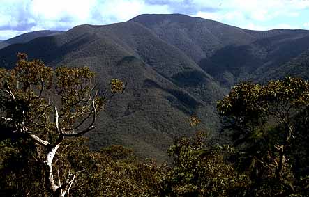
Above - Mt Paralyser and Mt Cloudmaker (far left) from Mt Bulagowar
The best time of the year to do the walk is sometime close to the Equinoxes. Summer provides long daylight hours but is too hot for the long climbs. Winter is a much better time for walking but it gets dark too early. Probably April-May and September-October are best. If possible choose a time of full moon or at least a waining moon - so that there is moonlight in the evening. This greatly assists the Friday night part of the walk when most parties walk to or near the Coxs River. Moonlight is particularly beneficial on Narrow Neck - allowing you to walk faster. Even on an overcast night it helps. Most parties would start the walk around 6 or 7 pm from Katoomba on the Friday night and expect to walk to at least 1 am.
To complete a three peaks walk it is necessary to go with the lightest minimum pack. Do not carry spare clothes (a spare set can be left in the car or cached at the start of the Neck). Carry a light sleeping bag, perhaps a cut down sleeping mat, a groundsheet . A torch is essential as well as a water container such as a wine cask bladder. If you are going with others then share a billy and fly. Carry a parka and warm clothing as it can get very cold along the way. Two maps - the Kanangra and Jenolan sheets need to be taken as well as a compass. In the past I have taken light weight long pants for scrubby sections or gaiters - but now would not take either. A first aid kit is perhaps optional - any walker doing the trip needs to be able to walk out if they get sick or suffer a minor injury. A spare torch bulb can be handy.
Food taken need to be light weight, have a high energy density and be easy to prepare when you are tired. Chocolate is a very good fuel. For dinner on some earlier trips I took some mashed potato powder that could be easily added to boiling water and a small tin of fish mixed with it. Now I would take a pack of 1 minute noodles instead of the potato. On the Saturday night it necessary to replace a lot of lost fluids - numerous cups of tea are good. For lunch I have taken prepared sandwiches - something I would never take on other walks. On The Three Peaks you do not have enough time to sit down and have a long meal and also you don't want to fill your stomach up too much but you do need to keep your blood sugar level high. A lot of small snacks are probably better. Breakfast on the Saturday morning is the hardest. Just after eating it you have to do a series of massive climbs. Something simple and light such as a couple of weet bix is OK. It is easy to feel nauseous climbing a hill after wolfing down some breakfast. On this walk you don't have enough time to sit back after meals and digest your food. On good thing to take is some fizz (fruit saline). At the top of a hill a cup of fizz is much better than a cup of water. Some walkers add glucose powder to the fizz.
In my opinion, the hardest part of the walk mentally is the Friday night slog along the Neck and then down to the Coxs. Along the Neck are a number of dry, enticing camp caves a short distance from the road and there is a strong tendency to pike. The caves should only be considered in very bad weather - then it is OK to "pike with honour". The small soak about a kilometre beyond the fire tower provides a reliable source of water and a good place for a short break and fuel stop. In cold windy weather it is better to stop in one of the caves above or below Taros Ladder. Allow about two hours for the Neck and then nearly one hour to descend down to Medlow Gap. A torch will be needed for this part. From Medlow Gap there is a choice of two routes.
The "traditional" route lies down the White Dog road to the river where camp is made. Then at dawn (or before 6 am) you walk up the Coxs to Korriecone spur which you climb. This spur is generally open and fast. You then reach the cliffs of the High Gangerangs and sidle left to Gentle's Pass. Compass navigation is required along the tops to Mt Carra (through light scrub) and then through thick heathy scunge to Dex Ck. The other route which has found favour in recent years is to go along the horse track from Medlow Gap to Mobbs Soak and then out to Mt Yellow Dog. Most parties would then camp on or just before the Coxs River. Next morning is a steep but open ascent up Strongleg Buttress. Then a faint track can be followed to near Mt Carra to join the other route. Often parties get lost or waist a lot of time in the thick scrub near Dex Ck. Some parties climb Mt Bolworra thinking it is Cloudmaker - a costly mistake in terms of time. Dex Ck provides a nice haven for a short rest and fuel stop. Half an hour or so away lies Mt Cloudmaker the first of the peaks. Do not spend too long reading the logbook on the summit. If you arrive by 8.30 am you are going well indeed. It is OK to arrive at the summit anytime before say 11 am. To have a good chance of reaching the summit of Guouagang that night it is good to be on Cloudmaker by 9.30 and Paralyser by 1 pm.
The route off the summit lies down The Marooba Karoo ridge. This is reached after descending over the bumps rumble and roar. The ridge is fairly open. Not far past the site of an old helipad put in to stop a bushfire the summit plateau of Mt Marooba Karoo is approached. Sidle the cliffs that are starting to the form on the left and go around to the large buttress ridge that drops to Thunder bend on Kanangra Ck. This ridge is very open and a very rapid descent can be made but be careful you follow the crest of the ridge. An alternative route to Kanangra Ck lies over Mt Stormbreaker and down the obvious ridge. Some parties have camped in Kanangra Ck and still completed the walk but this would be very hard to do.
When you reach Kanangra Ck it is worth carrying a little water with you up Mt Paralyser. The ascent is steep in places and often a real struggle after your earlier climb. It is one of the major psychological barriers of the walk. However as you climb the views get better and the ridge becomes less steep. The summit provides a good place for lunch. The log book can be found on the highest point of a fairly open woodland. If you have time it can be good to boil a billy of tea whilst on top. The buttress ridge to the north provides the descent route. After going through some light prickly scrub the ridge starts to become much better defined and very easy to follow. This is a "great" southern Blue Mts ridge - however it is quicker to leave it about two thirds of the way down and drop straight down to the bottom of Nooroo Buttress on the other side of the valley. This is a very steep descent and care needs to be taken with your footing.
Above - Mt Guouougang from Yellow Dog
Whalania Ck provides a spot for a short rest and drink before the big climb up Guouagang. Many parties would camp here - there is a good campsite at the junction with Jenolan Ck. In the past I have camped about tree hundred metres vertically up the ridge towards Guouagang - I have found it good to break up the big climb over two days and there are one or two reasonable campsites on the lower part of the ridge. If you have enough daylight left and are not too buggered it is good to climb to the top before camping.
Nooroo Buttress is not the psychological barrier that the ridge up Paralyser is even though it is higher and steeper. I think because it is the last of the Three Peaks it is not too bad. Also it is highly scenic providing good views of Davies Canyon and Mt Paralyser. Near the top, at Nooroo Gable some easy scrambling is necessary.
Once on the summit plateau it is best to head through the open forest than through the "shitis guougangii" scrub except for the last bit before the trig. The open forest provides a good sheltered campsite if you have carried up water. There are two routes off Guouagang. The "traditional route lies along the summits of the Krungle Bungle Range to Mt Jenolan and then down the remarkable open Gaspers Buttress to the Coxs River. Then the river can be followed upstream on the eastern bank to Breakfast Ck which is followed on the horsetrack to and up Carlon's Ck. Then another track is followed to the base of Carlons Head on Narrow neck. This is climbed via a set of chains and then a track is followed to the fire tower.
The other route lies over Mt Bullagowar and then down a long open ridge that leads to the Coxs river at the base of Yellow Dog (not Yellow Pup). There is reasonable camping on the saddle between Guouagang and Bullagowar and on top of Bullagowar. Once on the Coxs you ascend the open Yellow Dog ridge to Mt Yellow Dog and rejoin the route you used on the Friday night. You then walk back to Katoomba. I have used both routes and would now favour the latter one.
So that then is The Three Peaks. Why not give it a go? It way first done in 1957 by a party consisting of J Manning, Doug Dunnet, Snow Brown, M Elphicx, G Wagg, F Worral and Barry Higgins. This was before there was a road on Narrow Neck. The record for the trip seems to still belong to Warwick Daniels and John Fantini - 18 hours 22minutes in 1966. Probably about 3-4 parties a year complete a 48 hour trip.

Links to other Three Peaks web pages:
The Three Peaks in 24 Hours - an attempt by Athol Abrahams and Dave Dash of SUBW in 1966
Girls Gasping Through The Gangerangs - the first all girls attempt in 1966 by Denise Black and Carol Isaacs of SUBW
The Three Peaks - an attempt by Simon Angus and Matt Chambelain of UNSWBWMC in 1999. Their account is also here
The Three Peaks - an account by Emma Murray of her trip with Scott Morrison of UNSWBWMC
Two out of three ain't bad - an attempt by 3 walkers from ANU
The 3 peaks - a report by Dave Flimpyhead (2001)
An account by 2 Kamerukans in 1967