
This is a work in progress. Last revision 6 February 2024.
I grew up at Springwood and as a child was a frequent visitor along the tracks in Sassafras Gully, and also learnt to swim on family bushwalks to the large pool where Sassafras Gully meets Glenbrook Creek – which was named “The Lagoon” on early maps. Since then, I have visited the area on a regular basis, with a particular interest in the fungi that is found there. Also, on these bushwalks I have wandered along some old tracks and thought about when they were made.
It has been interesting looking at old maps and searching old newspaper articles and guidebooks that are online at Trove. I expect to update these notes if I find errors or more information. Any new information from readers will be greatly appreciated.
Aboriginal History
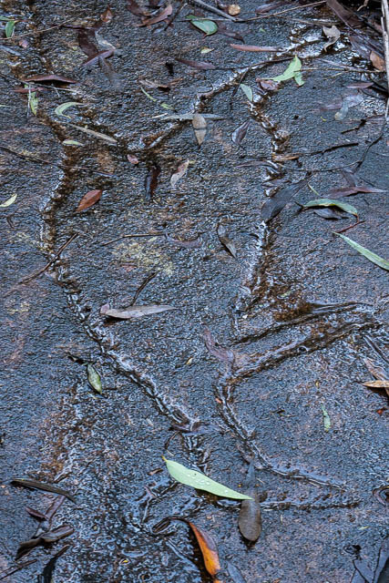
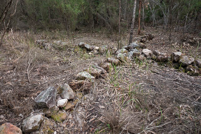
There are signs of a rich history of Aboriginal occupation in the main valleys and the smaller side creeks, and on the ridges above. This includes cave art, rock engravings, occupation shelters, stone tools, and sharpening grooves.
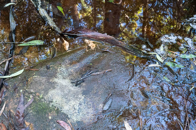
Here are some sharpening grooves high up in a tributary creekbed.
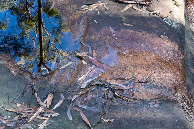
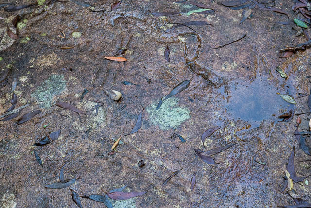
And in another creekbed –
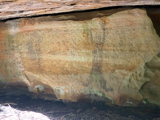
Here is come charcoal cave art, in small shelter cave in one of the main creeks –
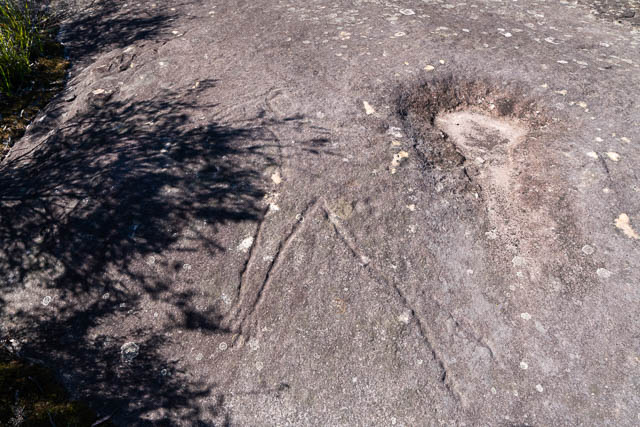
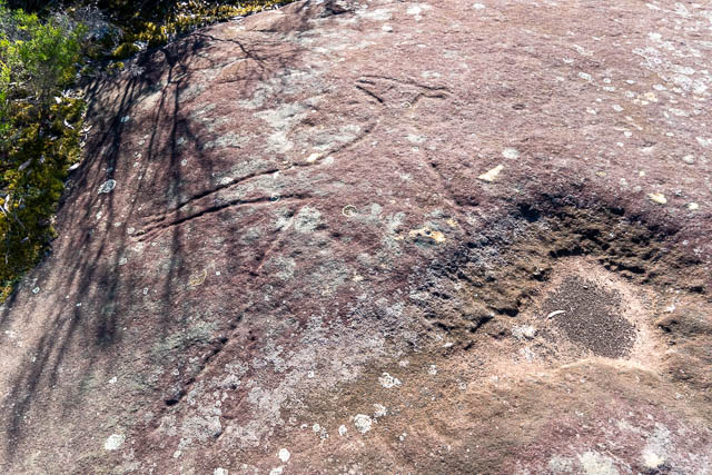
These engravings are in a tributary creekbed, high up. The first is a kangaroo.
This one appears to be a large snake –
This engraving, probably a kangaroo, is on a large rock platform on a ridge above the creeks –
And some stone tools found in occupation caves –
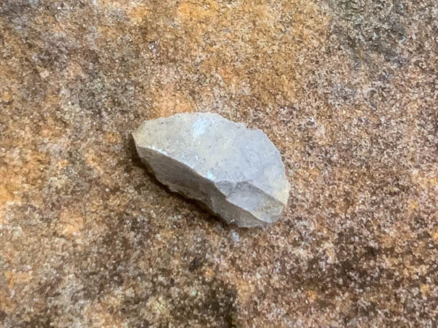
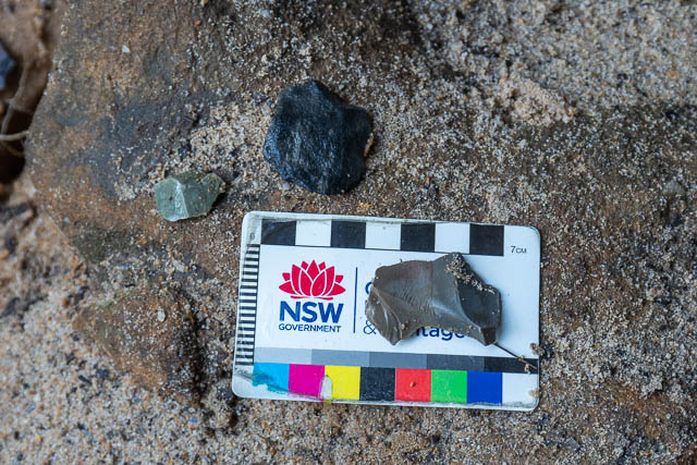
These rocks are not local to the area and have clearly been imported. Their edges have been worked.
William Dawes
According to this post on the Blue Mountains Local Studies blog, by John Merriman, the first European to visit Sassafras Gully was William Dawes, on his attempt to get to “Round Mountain” (Mt Hay) in 1789.
With Round Hill as a landmark, Dawes headed directly for it and crossed the main ridge, dividing the waters of the Grose and Nepean, at a point somewhat east of Warrimoo Station.
Continuing, at least six major creeks that drain southward from Valley Heights were crossed – an arduous task requiring considerable effort in climbing into and out of them. In fact, the whole of the journey involved ascending and descending the gullies of the Lower Mountains.
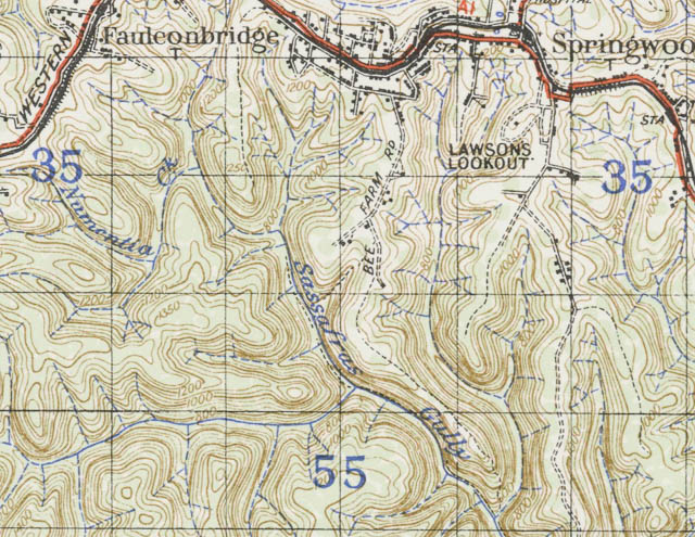
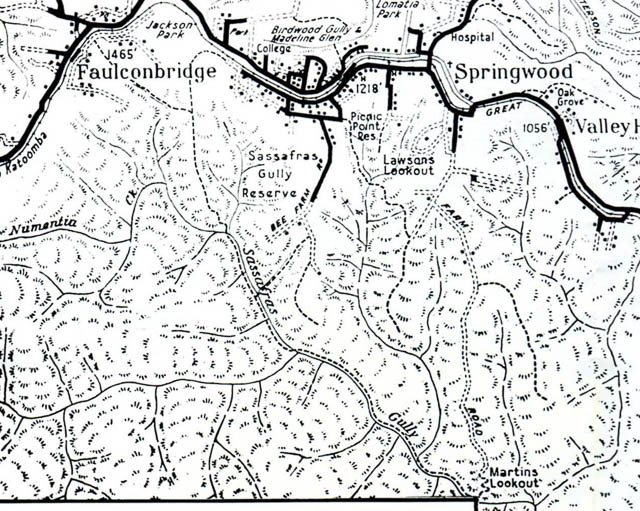
Dawes crossed the ridge south of Springwood near the last house in Farm Road, next to the Bee Farm Road ridge which was crossed near the Rifle Range. Down into Sassafras Gully onwards to the main ridge about Faulconbridge Station.
More early history of Springwood can be found on the same blog, on this post with some more on a later post.
When was the first track constructed that went down to Sassafras Gully? I am not sure. Probably not long after the railway was built in 1867.
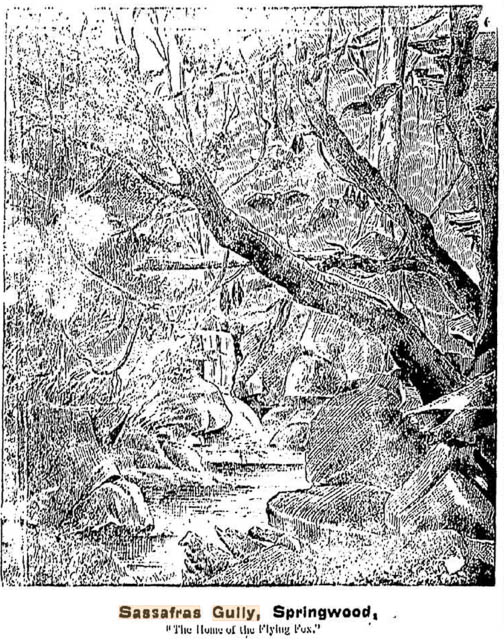
Flying Fox Gully
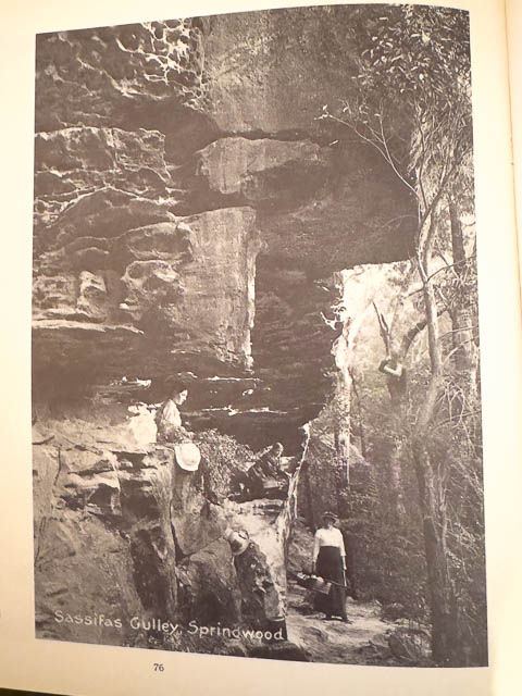
I knew that Sassafras Gully was originally called “Flying Fox Gully” and wondered why the name was later changed to “Sassafras Gully”. An article from the The Sydney Daily Telegraph, 23 February 1881, Page 4 may explain why.
A visit was paid on Saturday by a large party of gunners to the ” home of the flying foxes” at Springwood, the orchards of which district suffer greatly from these pests. A number of Sydney men went up by the excursion train in response to a general invitation from the fruit growers, and were met at the station by the local detachment. After a short adjournment to host Springwood’s, a general move was made, under trusty guidance, to the scene of the day’s operations, the bottom of a rocky gorge about 500 feet deep and two miles distant from the township. The precipitous descent, over huge boulders and down the slippery, uncertain track, having been accomplished with nothing worse than bruised shins and wet flannels, the gorge itself was found to be well worth a visit, being, perhaps, one of the most beautiful natural ferneries in the world. The party, however, did not stop long to botanise, but quickly found the foxes hanging in dense clusters, to the number of some thousands, in a huge sassafras tree, and a deadly volley from nearly 20 guns awoke the echoes of the cliffs and strewed the mossy ground with the dead and dying. Then a general fusillade began, the gunners posting themselves apart for a mile or more along the valley, and giving even the breechloaders full play.
And there is more –
This lively work having lasted for four or five hours a new zest was given to the sandwiches and the contents of the flasks so thoughtfully brought, but the camp was rudely disturbed by the sudden appearance of a black diamond snake more than three feet in length in the midst of the reclining groups. A loaded gun was snatched up and in a moment the snake, which had come out of a log on which one of the party was sitting, diversified the trophies of the day. Towards evening the beetling cliffs were clambered, and the foxes left to count their losses, which have not been so great for many a day. Although shooting flying foxes may not please a fastidious sportsman, yet it is a useful amusement, like a kangaroo battue, and there is plenty of it, and some may like that better than wandering about all day without a shot in search of nobler game. On the wing the foxes offered good practice, and many visitors to Springwood will see some very pretty country and be made welcome at host Martin’s excellent hostelry. Perhaps the other recommendation of being able to obtain a beautiful collection of ferns, may be a stronger inducement to some who like conservation better than destruction, to visit ” Flying Fox Gully.”
So if you don’t want to shoot flying foxes, then you can help yourself to the ferns to take out with you.
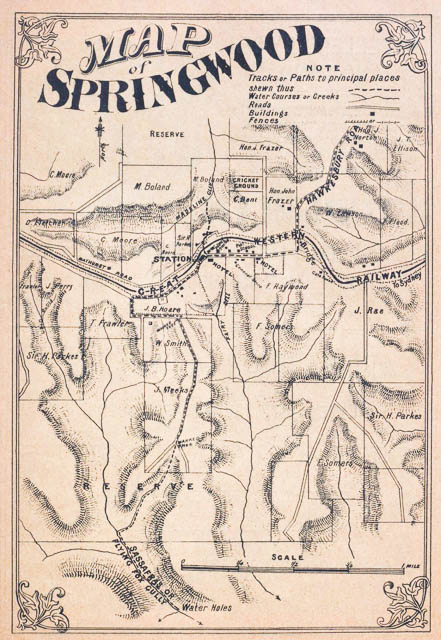
J E M Russell’s 1885 “The pictorial guide to the Blue Mountains of New South Wales and to the districts between Parramatta and Bathurst including the Jenolan Caves” has notes on Sassafras Gully and a map showing the tracks. It calls the gully – “Sassafras Gully or Flying Fox Gully”and the track marked on the map goes from the back of T B Hoare’s Homedale Property, along the ridge to a marked tree at the corner of the present Bee Farm Road and Yondell Avenue. The track then followed what we now call the “Wiggins Track” down to Sassafras Gully and then went downstream to Glenbrook Creek.
The Wiggins family were the apiarists of what was later named Bee Farm Road. And members of the family served on the Reserve Trust for Sassafras Gully and were responsible for some of the track building. But the Wiggins Track seems to have been the first track and may have been constructed before their time. The family resided at Springwood from about 1885. The Flying Fox article above indicates that there was an “uncertain track” in 1881.
The present day Wiggins Track does not start from Bee Farm Road, but a short way along Yondell Avenue. I have not been able to find the origin of the name “Yondell”. Possibly something to do with being beyond Fairy Dell.
A Blue Mountains Council Register Review states that the Wiggins Track was constructed between 1879-1882.
The Nepean Times 15 May 1886, Page 2, reports that the “road shall be cleared for vehicles”. I assume that this is Bee Farm Road.
In 1887, The NSW Government Gazette has a notice revoking a 350 acre recreation reserve in Sassafras Gully and replacing it with a 723 acre reserve for public recreation.
Another guidebook in 1888 describes the way to the start of the track –
SASSAFRAS, OR FLYING FOX GULLY.
This lies about a mile and a half south of the railway, and can be approached by a path from the back of the Royal Hotel. The way leads through the bush, over a fence or two, past the quarry, and diverges to the left at the Bee Farm.
And adds –
The flying foxes, who in fruit time make the valley their home, hanging the advance guard of their foraging army upside down to the tree boughs, are not so numerous as in past days of undisturbed seclusion.
(Horrocks’s Handy guide to the Blue Mountains and caves of New South Wales / compiled by J.H.S.)
The description continues –
After a somewhat lengthy descent over the rocks and down among the unclothed tree stems, the valley debouches into another gorge of still more romantic beauty. Along the centre channel of the defile are chains of water-pools, broad and clear and motionless, forming the flooring of a lofty tunnel to which the over-arching trees are sides and perforated ceiling. On the still, transparent surface of the water dead leaves and wandering, bracken fronds are floating. Like specks upon a mirror they break tire faultless reproductions of this liquid looking-glass. From the pure water graceful curves of green seem reaching up to touch the points of overhanging ferns. Boulders muffled in moss, grey tree-stems, swinging loops of creepers, gleams of light through leafy interspaces have here their colour symphonies reflected and refined.
All the trees are tied by festooned supple-jacks. Swaying wooden ropes, thick as a man’s arm, or in some parts slender as his finger, but always lissom, hang from upper boughs, or swing in twisted lengths from tree to tree. Long loops of natural cordage unite the forest masts, tie themselves in knots unknown to sailors, hang in distorted shapes.
A New Track
It seems that in 1889 a new track was made into the valley and improvements were made such as the installation of seats along the way.
The Nepean Times, 29 June 1889, Page 4, reports –
Anyone wishing to see the last tree fern in Sassafras Gully had better go there at once after reading this item ; Sunday will be too late, for that’s the day generally selected for pillaging. Since the new paths have been made it is so handy to renew our ferneries or make a shilling or two in Sydney market.
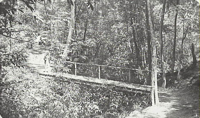
Photo – Blue Mountains City Library
And in 1890 The Australian Town and Country Journal – 2 August 1890, page 17 –
Improvements nave recently been made by the trustees of the Sassafras Gully in the path which leads for miles along this pretty reserve. Seats have been placed at convenient distances for the comfort of visitors.
Back to Nepean Times (Penrith) 9 August 1890. Page 7 –
How many of our readers have visited that beautiful spot called Flying Fox, or more recently, Sassafras Gully, at Springwood. To those who have not done so at all, or who have not been there recently, it may be pointed out that the new path to it, is far easier and equally as pretty as the old one; and it has certain other advantages which the old track does not possess. In the new route the descent is commenced from a point much nearer the main road, and the water course is thereby reached much sooner than by the old track. Comfortable seating accommodation has also been provided at easy distances along the whole way to the lagoon at the end; this will be highly appreciated by visitors generally, for although the trip is to most people a very enjoyable one, occasional resting adds considerably to one’s pleasure. Especially is this so when one reflects that he has to climb a height of some six hundred feet in ascending from the gully.
The “new route” seems to be the track that starts from the end of Sassafras Gully Road.
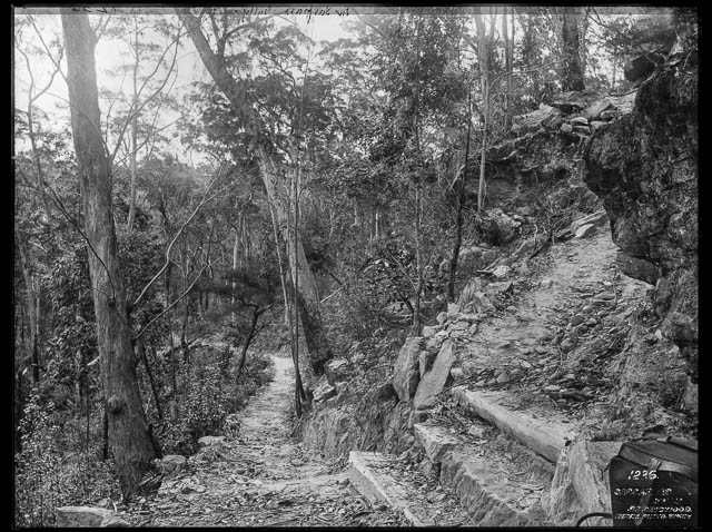
Photo – Charles Kerry & Co. and is part of the Powerhouse Museum’s Tyrrell collection
Lost Walkers
In The Nepean Times, 23 August 1890, page 3, there is a report of two ladies in a party of five that had entered the valley by the new track, where separated when they attempted to walk out via the old track and lost their way. Blundering around in the dark, one had fallen down a cliff. They were located at 9 pm.
There are more reports of lost parties in 1891. In 1892, the Katoomba Times, 16 September 1892, Page 3 reports that two “shootists” were lost, but the constanble sent to search from them instead found two girls that had been lost. They were “ brought up in triumph at about 3 o’clock on Monday morning”. Meanwhile the “shootists” found heir own way out, on the Monday morning.
In 1893, in the depression, there were no funds for the trust to improve the track.
There was another search in 1895 for three missing girls. They were found downstream from The Lagoon, where there is no track.
The path is made as far as the lagoon, and it is dangerous for any but those experienced to proceed further. The ladies appeared to think that by going they were working their way back to Springwood whereas they were going on towards Glenbrook.
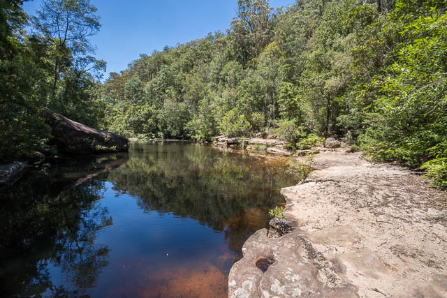
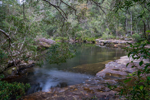
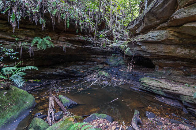
The Lagoon
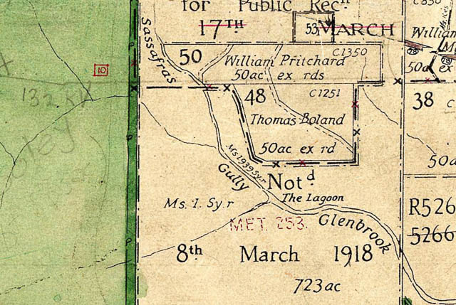
This was the name used for the large pool at the junction of Sassafras Gully and Glenbrook Creek. It is great natural swimming hole. The name appears on old Parish maps. There is very little development in the upper catchment of Glenbrook Creek so the water is fine to swim in.
The Trust
In 1897, The Mountaineer, 18 June 1897, Page 2 reports –
Mr E. Wiggins has been appointed as a trustee of Sassafras Gully Reserve and Lomantia Park in lieu of Hon Dr Norton, resigned.
Soon after, The Nepean Times (Penrith). 17 July 1897, Page 4, reports –
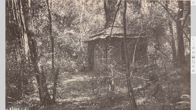
Trustees for Sassafras went down into the gully to see how they, could best spend the money voted for this year. They decided to have a weather shed erected, and a fire place built for picnic parties, also to have direction boards placed at the most necessary places
It did not take long to build the shelter shed. The Nepean Times 28 August 1897, Page 4 –
The shed, etc, have been completed in Sassafras Gully and should prove of great convenience to picnickers.
This shed was located near The Lagoon.
In 1900, at the Springwood Progress Association, a motion was carried to ask the Sassafras Gully trustees to put up notice prohibiting open bathing in The Lagoon.
I am not sure what “open bathing” meant in 1900. Perhaps it refers to taking a bath in a pubic place rather than swimming. And this was a time before swim wear was common.
The Mountaineer (Katoomba) has an article on Sassafras Gully (23 March 1900. Page 2) and has some interesting information –
But Sassafras Gully is the place to which we hasten. This was once called Flying Fox Gully on account of the myriads of those nocturnal creatures that inhabited the ravine. The gorge is wonderfully romantic and full of interest, and the fine lagoon is without a rival.
The gully is entered by a well made track a little westward of the town, but there is also another entrance. The descent is easy and one soon feels they have entered Paradise. Everything around appeals to the artistic senses. Originally the delicious floss was lavishly abundant. Even now it abounds in transcendent beauty.
Soon a break in the path is reached, and this is marked by a veritable Fairy dell with a miniature waterfall. In places the sides of the gully narrow till the foliage overhead is entangled, and when the light penetrates under such circumstance the effect is striking.
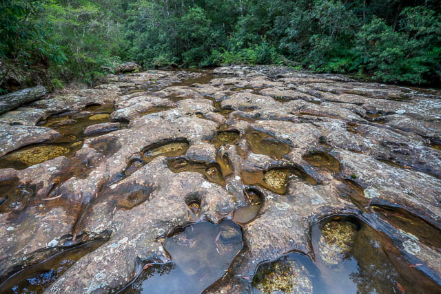
The singing burn ripples by the path all the way, and as you near the lagoon the gully widens out. Soon the stream widens out into pools, and further on is joined by a larger stream. Here a peculiar formation is met with. The limpid stream spread over a rocky base, which is worn into fantastic channels and pot holes. This would form a study for a geologist, and from it he could read past history as in an open book. Soon the lagoon is reached — one of the finest sheets of water that nestles in the bosom of the Blue Mountains.
I don’t think the “Fairy dell” referred to is the present Fairy Dell in the headwaters of Magdala Creek. I think the author means the original track (Wiggins Track) and the new track (Sassafras Gully Road). The well made one is probably the Sassafras Gully track.
The author also refers to the interesting pothole formations in the streambed of Glenbrook Creek just before The Lagoon.
Vandalism is reported in 1902 – Nepean Times, 26 April 1902, Page 6 –
I understand a few pounds have been granted for the different reserves about Springwood. It will be a pity if the scoundrels who take the trouble of going down Sassafras Gully and throwing the seats out of place, and otherwise destroying the track, ever get the job to replace them.
Martins Lookout.
From The Nepean Times, 31 October 1902, Page 4 –
As arranged, the Springwood working bee, consisting of about 11 residents, armed with axes and mattocks, went out on Monday last and cleared a road through the scrub to what is known as ” Martin’s Look-out,” This new pleasure resort is one which should prove very attractive to Springwood visitors, especially to those in delicate health, as they can drive right to the spot—only a distance of about 3 miles from Springwood. The view from this look-out is grand in tho extreme. Standing upon a mountain crag, one looks out over an expanse of the wildest and most beautiful scenery imaginable. A combination of colors meets the eye. In the distance loom heavily timbered mountains, with abrupt cliffs standing out in bold relief, while hundreds of feet below the valley is clothed with a dense undergrowth of ferns, waratahs, and Christmas trees. A beautiful stream abounding with fish traces the ravine, which, if followed np a short distance, brings one to a magnificent waterfall.
I think this waterfall would have to be Martins Falls in Magdala Creek.
Next, The Nepean Times, 15 November 1902, Page 6 –
The Springwood Working Bee is to do another day’s work on Monday next on Martin’s Look-out Road. Od Monday last this new pleasure resort was patronized by a number of people. Quite a number of traps made use of the new road. We hope another day’s work will make it fairly good to travel on.
And, The Nepean Times 22 November 1902, Page 6 –
On Monday last the Springwood Working Bee turned out for the second time. The day was very hot, and only six turned up; but they succeeded in cutting a track from the top of Martin’s Lookout to the creek at the bottom.
There are two separate tracks down from Martins Lookout to Glenbrook Creek. It looks like the first one was built in 1902.
Another Report
The Lithgow Mercury. 4 March 1904, Page 3, has an article on Sassafras Gully written by “Graplio”. The author enters via the track from Sassafras Gully Road and describes the shelter shed –
The distance is about two miles from the starting point to the shelter shed. The shed is made of rough hewn slabs and an open front, with galvanised iron roof, furnished inside with rustic table and seats.
And then describes The Lagoon –
A walk over the honeycombed waterworn bed of tho right stream brings one to the lagoon, formed by the meeting of the two streams. It is a small, shallow pond, its bottom a bed of yellow sand.
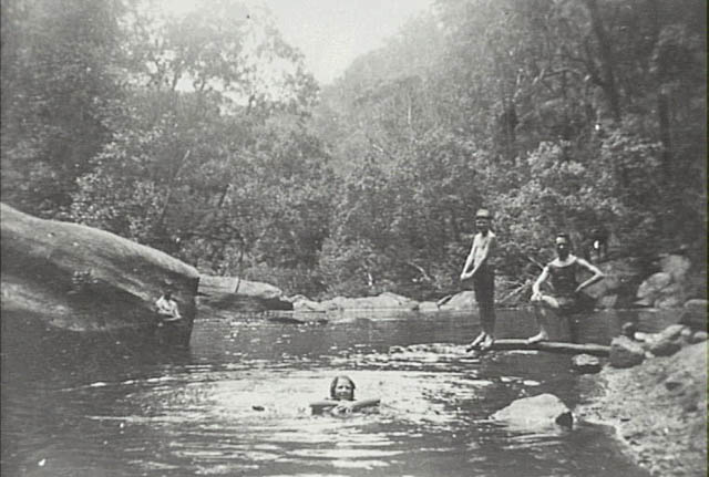
Photo – Various views from Alf Sully’s photo album – Blue Mountains City Library
Mountain Mystery
In 1903 a body was found in “Clift’s Gully” by James and Walter Wiggins and their father and two others. They were walking to Linden. See this report of the inquest in The Nepean Times, 18 April 1903, Page 6. The gully was supposed to be “five miles from Springwood” and in a south west direction.
James Wiggins was the one who found the body – a skeleton. The skull had been separated, probably by an animal, and was not far away (5 yards). Further away (150 yards), were the person’s shoes, placed neatly together, and his and socks were found in a different direction. Sticks were also found that had been used as walking sticks. James’s brother, Walter Wiggins walked out to Springwood the next morning and contacted the police.
It was estimated the person, who was later identified as Samuel Henry Mansell, 49, bootmaker of Bathurst, had died about 2 months before his body was found.
It seems he was out of work and travelled to Sydney to find a job, Unsuccessful in this, he had set out to walk home. He had camped near Linden with some other tramps when he disappeared at night. He had said he was going down a gully to search for water. When he did not return the other tramps assumed he was on his way to Lithgow.
The coroner found he had died from exposure and starvation.
I have never heard of “Clift’s Gully”, but it must be a tributary of Sassafras Gully or Glenbrook Creek. I think a tributary of upper Glenbrook Creek or in Namantia Creek is more likely since the party that found the body were on their way to Linden, and the body was found at about 6pm. But we don’t know if the 5 mile distance was in a straight line or along tracks and creeks. When the body was found, the party stayed there as it was too late to return to Springwood. The next morning, one member of the party did walk out to Springwood (not Linden or Faulconbridge).
Further research – I have found ( see the chapter on Numantia here) that Sir James Martin’s house “Numantia” located between Linden and Faulconbride was later occupied by J W Cliff (and it was later purchased by Adolphus Rogalsky, who served on the Sassafras Gully Trust – see below). I think that “Clift” and “Cliff” are one in the same. Cliff then moved to “Weemala” (later called “Eurama”) and occupied the house between 1889 and 1896 ( See this source). The property was owned by George Evans when the body was found in 1903.
Different newspapers have the same report and all have the gully spelt “Clift”, but they all probably used the one source as the text is identical.
So where is Clift’s Gully then? It could be be the present Numantia Creek or it could be a tributary of upper Glenbrook Creek or Glenbrook Creek itself. I think the fact that Walter walked out to Springwood suggests Numantia Creek is more likely. It was not named or known as Numantia Creek in those days.
Numantia Falls was on a property purchased by Sir Alfred Stephenson. He constructed a track to the falls.
Magdala Creek Track and Yondell Avenue Track
In 1906, The Nepean Times – 1 September 1906, Page 4, reports that “tenders are called for forming paths in Sassafras Gully Reserve”
Next, The Nepean Times, 15 December 1906, Page 6, reports –
The Sassafras Gully trustees met at the Royal Hotel on Wednesday night, for the purpose of considering tenders called for work on that reserve. The tender of Bernard Forde was accepted for forming a new path from Springwood, connecting with a number of paths, a distance of about 1¼ mile, for the sum of £18 10s. Other tenders, for alterations and putting in order Sassafras paths, were rejected and fresh tenders called for the work.
Probably this new path from Springwood is the track down Magdala Creek.
Soon after, another report confirms this. From The Nepean Times, 19 January 1907, page 6.
The grant of £50 has been expended in the reconstruction and renovation of the track leading to Sassafrass Gully. The work, which was undertaken some months ago, is now satisfactorily completed. A track has been constructed from the Railway Station travelling in an easterly direction down Springwood Gully for a distance of about 3 miles, and returning up Glenbrook Greek a distance of another mile; then connects with the original Sassafrass track completing a circuit of about 7 miles. Much time and labour has been devoted to the construction of laying out of these paths. Intending visitors may now avail themselves of said paths without the arduous task of climbing precipitous grades.
“Springwood Gully” was an old name for Magdala Creek. Now the walk and become a loop – where people could start walking at either The Wiggins Track or the Sassafras Gully Road Track and walk to The Lagoon, then continue down Glenbrook Creek and exit via Magdala Creek (which has a gentle gradient).
The next year, The Nepean Times, 27 June 1908. Page 3 reports that the trust had accepted a tender from E Wiggins for £86 for clearing a road and other work. This is likely to be the fire trail along Yondell Avenue and the track down to “Upper Falls”. This is supported in a later report in The Nepean Times 18 July 1908, page 3 –
Several of the new paths on the different reserves are nearing completion. Mir Wiggin’s new road, promises to be of great benefit to the district, for when completed visitors. will be able to drive within 800 yards of the Falls, one of the best sights we have. On Martin’s Lookout Mr Oronoher’s contract is going well, and when finished will make a splendid park, especially if the trustees plant a few ornamental trees for shelter.
The “Falls” would be what were then called “Upper Falls” now known as as Magdala Falls.
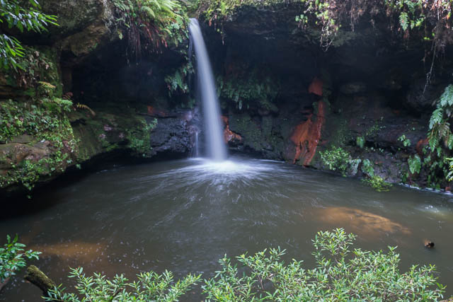
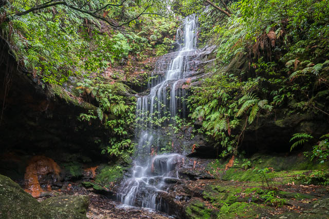
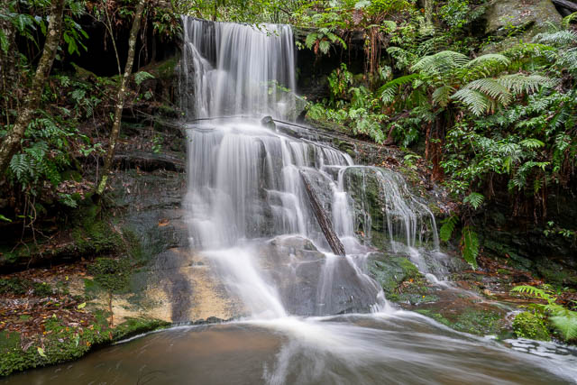
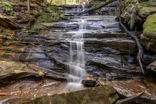
Upper Falls (Magdala Falls)
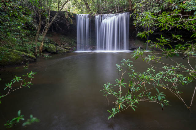
Lower Falls (Martins Falls)
Around 1970, Springwood Bushwaking Club published a book of daywalks by Wilf Hilder. One of the walks –
SPRINGWOOD – Sassafras Gully – path – Glenbrook Ck – path – Springwood Gully – Upper Falls – Spur – 563.326 – track – Bee Farm Rd Springwood. 6m.E
The grid reference applies to the old 1:63,360 Windsor topographic map and is the end of the spur along the Yondell Fire road. So Wilf Hilder, or his contributors, knew about the old track down to Magdala Falls from the end of Yondell Ridge.
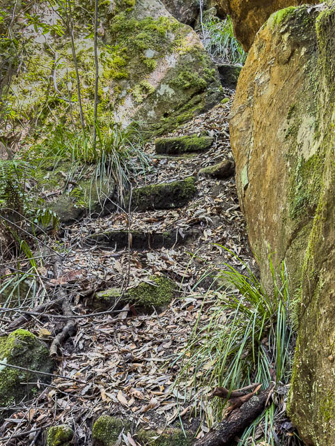
This track from the end of the Yondell Ridge seems to have fallen out of public use around that time. It soon became overgrown until it was re-cleared around 2021.
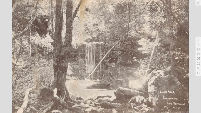
Photo – Lower Falls, State Library of NSW
Acclimatisation
The Nepean Times – 26 September 1908, page 5, reports that two tanks of trout were taken down to Sassafras Gully and released.
It seems that this attempt to stock the creek with trout failed like similar attempts made at at Govetts Creek in the Grose Valley.
Another Guidebook
In 1908 another guidebook was published – The Mountaineer Illustrated Tourist Guide to the Blue Mountains and Jenolan Caves.
Part of the description of Sassafras Gully –
The Gully passes a really lovely, smiling lagoon, where there is a picnic shed. Finger posts indicate the round track, returning by a different route, passing on the way another picnic shed, then Lower and Upper Falls.
So it seems a second picnic shelter was constructed – at the junction of Magdala Creek and Glenbrook Creek. There is a large flat area there.
Springwood Falls
The Nepean Times, 21 August 1909 has a brief report –
Tenders are invited for forming and making pathway 8ft 6in wide from the junction of Sassafras and Springwood Falls Roads to the shed on Martin’s Look-out, Springwood.
This is a puzzle. There is a “Sassafras Gully Road” and that name has been used for a long time. There was also once a “Sassafras Park Road” marked old parish maps which was on the north side of Springwood, and seems to have been renamed “Churchill Road”. But I cannot find a “Sassafras Road”. And where is “Springwood Falls Road”? There is a Springwood Avenue on the south side of the shops at Springwood. I think Springwood Falls is the waterfall in Magdala Creek just downstream of where the Fels Pass Track joins the Magdala Creek Track. The old name for Magdala Creek was “Springwood Gully”.
So where did the proposed pathway go? Is it the track down Magdala Creek and then up to Martins Lookout? No, see above, that was made in 1907. Perhaps this pathway was never constructed?
Faulconbridge Gully and The Victory Track
From The Blue Mountains Echo, 25 December 1909, Page 25 –
Faulconbridge, 49 miles, 1,465 feet, is named after the property of Sir Henry Parkes, one of New South Wales’ foremost statesmen, whose remains now find a fitting resting place in the quiet little churchyard hard by. Faulconbridge Gully is well worth a visit, and is within a few minutes’ walk of the station. The Terraced Gardens, Rocklily Glen and Cave are very characteristic and charming localities much admired by visitors.
I have not been able to find information on when the Victory Track was constructed that linked existing tracks used by Sir Henry Parkes and his family and the Sassafras Gully Track. The Blue Mountains Heritage Register Review states the track to Clarinda Falls was constructed between 1878-1887. The remainder of the track that links to the Sassafras Gully Road Track was constructed later – perhaps between 1907 and 1915?
The original name for the track was “The Long Track” and that name was changed sometime after World War 1 to “The Victory Track”. Faulconbridge Gully also seemed to be called Parkes Gully.
The Rocklily Cave can be found short distance down the track. The floor of the cave has been excavated, probably for a picnic table.
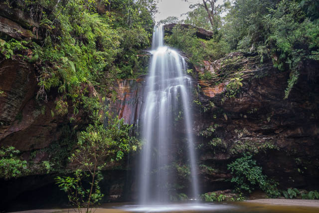
Further along that track can be found Clarinda Falls, named after Clarinda Varney, Sir Henry’s first wife.
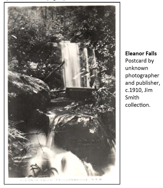
Clarinda Falls
There is also Eleanor Falls, probably named after Sir Henry’s second wife, Eleanor Dixon. I have found two waterfalls that could match an old postcard published in Hut News. One location is above Clarinda Falls in the main creek. The other location is in a side creek, known as Parkers Gully, coming in from the west just below Clarinda Falls. I now think this waterfall is the most likely candidate for being Eleanor Falls. The top part of the waterfall matches the postcard photo, which I think was taken at an angle that shows a foreground cascade and misses the lower part of the main waterfall.
Eleanor Falls
Further downstream Parkes Gully joins the larger Numantia Creek. Here there is also a rough side track to Numantia Falls. I am not sure if this was once a constructed track or one formed over the years by bushwalkers passage. However, I think it is likely that it is actually a continuation of Sir Alfred Stephenson’s track from his Alphington property to Numantia Falls., and then continued on to Parkes Gully. The way the lower part of the track traverses at a high level in places suggests it was a constructed track.
Numantia Falls
The Sassafras Gully Case
In 1920, the body of a old age pensioner was found in a cave in Sassafras Gully. Apparently the pensioner had been living in a cave known as Phillips’ Cave.
From the report of the inquest ( Nepean Times, 10 January 1920, Page 1) –
when ascending the gully and crossing over the top of Phillips’ Cave, I saw the body of a dead man
The person died of natural causes.
I have no knowledge of where Phillip’s Cave is. It is hard to think of a place where the track crosses over the top of a cave, and cave big enough for someone to live in. Blue Mountains local historian John Low has suggested it may be the cave depicted in a photo. The photo taken by Blue Mountains photographer Harry Phillips, shows visitors resting in an overhang near the track. The photo is not dated, but another by the same photographer taken in Sassafras Gully is dated 1914. If the photo was used in a postcard that was sold locally, then the depicted cave could have been referred to as “Phillips’ Cave”.
In April 2023, I located the cave depicted in the old photo. The track going down Magdala
The photo is on page 76 of “The Far Framed Blue Mountains of Harry Phillips” by Phillip Kay (second Back Row Press, 1985)
In April 2023, I located the cave depicted in the old photo. The track going down Magdala Creek passes through the cave, not far downstream of where the Batman Track joins it.
From this location, I think it is very unlikely to be the cave where the body was found. It does not fit the inquest description and it does not seem to be a suitable cave to be occupied by a homeless person.
Some New Tracks
In 1921, The Blue Mountains Echo, 4 Feb 1921, page 6 reports –
The Trust of the Springwood and Linden group of Mountain reserves, has accepted the tender of J. J. Wiggins to make and form a new track in Sassafras Gully, leading from the Valley Road, alongside the old Government quarry and across the creek. A track also is to be formed and made from the bridge to Smith’s shelter shed
I think this must be a track from Picnic Point to Fairy Dell.
Perhaps Smith’s Shelter Shed?
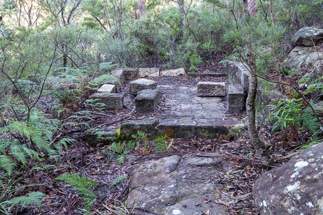
Photo – Sassafras Rest House, State Library of NSW
In 1927 – The Blue Mountains Echo. 11 Feb 1927, page 6, reports –
At a meeting of the Trust of Local Reserves they voted for the “demolition of the old rest house at Sassafras Gully, and the replacement of a number of steps. Mr. Rogalsky piloted an appeal for a new track through the School of Arts ground, crossing near Tabor’s, and connecting with that portion of the adjoining gully in charge of the Trust. This would afford easy across to Picnic Point and prove a great asset.
This sounds like the current track down Fairy Dell. The Springwood School of Arts was in the main street of Springwood amongst the shops. “Mr Rogalsky” is likely to be Adolphus Rogalsky. The Blue mountains Local Studies Blog –
In 1898 Adolphus Rogalsky purchased Numantia and it was he who changed the name to Weemala. This coincided with the name change for the other Weemala to Eurama.
These properties are in the headwaters of Numantia Creek. Originally owned by Sir James Martin (who Martins Falls Martins Lookout and the two Martin Places in Faulconbridge and Linden (as well as the Martin Place in Sydney) is named after)
The Nepean Times, 2 July 1927, Page 7 –
The new park at Picnic Point had been partially cleared, and provision would be made later for tables, seats, and, possibly, a shelter. This park was prettily situated at the end of Homedale Street, within a few minutes walk of tho town, and no doubt would be largely patronised when completed. Later on, the forming of a track, through the School of Arts grounds, and through Mr H. E. Tabor’s property (by his kind permission) into Springwood Gully and then on to the new park at Picnic Point would be proceeded with, thus providing easy access from tho centre of the town to the gullies and the new park. This would fill a long felt Want – a public park within tho town area.
And it looks like a shelter sheds were finally constructed at Picnic Point at the end of 1932 or in early 1933. The Nepean Times, 10 December 1932, Page 1 –
The Lower Mountains Reserves Trust has accepted the tender of Messes Stratton Bros, for the erection of shelter sheds, water tank, etc, at Picnic Point, Springwood.
Parkes Gully
From The Sydney Morning Herald, 13 April 1922. Page 10 –
PARKES GULLY.
———-o———-
GIFT TO THE PEOPLE.
———-
PUBLIC PARK.
———-
Messrs. Allen, Allen, and Hemsley, solicitors for the Allen Estate, Faulconbridge, Blue Mountains, have arranged, through Councillor J. T. Wall, for the Blue Mountain Shire to accept dedication of, about 250 acres of the estate as a reserve for the people. The area comprises a large portion of the sequestered ground of the late Sir Henry Parkes, and is known as Parkes Gully. It is right near the railway station, through which a track has been formed, connecting up the famous Sassafras fern-laden walks.
I think the “sequestered ground” refers to Sir Henry Parkes having to liquidate much of his extensive Blue Mountains properties when he became bankrupt.
More Vandalism
In 1932 The Katoomba Daily, 6 August 1932, Page 2,carried this appeal –
It is high time that drastic measures were taken to protect public property from the ravages of that particularly obnoxious type of hoodlums who on every possible occasion wilfully and maliciously inflicts damage on our public parks and reserves. For many years tbe above Trust has been subjected to a great deal of trouble and annoyance, and considerable expense, through having to repair the continual havoc caused by these senseless and vicious vandals. Water tanks have been damaged and rendered useless, taps interfered with, iron roofs of shelters smashed by heavy stones thrown upon them, seats and tables pulled up and sometimes burned, direction signs defaced and destroyed, and other methods of destruction used which are too numerous to mention. Recently a magnificent turpentine tree in Sassafras Gully was felled and destroyed by means of dynamite, simply to secure a bee’s nest. To clear the track of this obstruction cost the Trust 30/-. The other fine trees were cut down in the same gully in order to strip the birds-nest ferns off them. A number of early flowering waratah buds were wantonly cut down and removed. In about six weeks time these magnificent native flowers would have been in full bloom, adding a touch of gorgeous coloring to the verdant gullies, and a source of delight to visitors. It is clearly the duty of the public to help to preserve these natural beauty spots which the Government provides and maintains for their free enjoyment, and if patrons would promptly report any outrages of this nature brought under their notice. It might enable the local authorities to take immediate action with a view to punishing the culprits. The Trust have now instituted special methods of espionage and have determined that in future any person found unlawfully damaging, disfiguring, removing or otherwise interfering with the property under its control, or infringing the regulations governing same in any way, will be
severely dealt with and a heavy penalty pressed for, along with compensation for any damage incurred.A. SCANLAN,
Secretary, Blue Mountain Sight Reserves, Faulconbridge
Part of the Windsor 1:63,360 map
Sassafras the Writer
In 1939, the Blue Mountains Daily, a Katoomba based Newspaper published a series of three articles by an author using the pen-name “Sassafras”.
In the first part, published 10th March 1939, the author mentions two tracks, one from Bee Farm Road and one from Sassafras Avenue. The author recommends the longer track from the at Sassafras Avenue, calling it the “Rest Shed Track” and noting the Lyrebirds that may be seen and heard along the way, and adds that Platypus have been observed. On the way a track joins from Faulconbridge and Parkes Gully. Boys used to be able to swing in on the monkey vines until they were chopped down by council after a boy fell and split his head open.
Could this be the remnants of the Rest Shed? It is a short way down the track from Sassafras Gully Road
Then the track opens up at “well built rest house” at the junction of Sassafras and Linden Gullies.
The author adds –
Most fascinating of all, however, is the gigantic rock over which the Linden water flows into the pool. Fifty yards by fifteen, its surface is riddled with hundreds of potholes, each filled with water. It always reminds me of a huge sponge
The second instalment was published on 17th March 1939. The author talks about the track from Faulconbridge via Parkes Gully and Victory Pass. The author describes walking upstream towards Faulconbridge –
Victory Pass is practically level walking until the gully divides. To the right is Parkes Gully. The left is trackless, and leads to “Eurama.” In it are a pretty little waterfall and a sphinx-like rock said to be connected with the aborigines.
This waterfall would be Numantia Falls. The author is impressed with Clarinda Falls –
A sparkling cascade splashes fifty feet into a charming grotto. The walls are entirely of stalactites and stalagmites, miniature and of a moist greenness. A floor of sand redeems the sombreness. It is a dream phantasy of nature unparalleled in my experience.
Then, another track is described – the “Karandra Track”, that goes along the railway line to reach Railway Parade and you can follow a cart track along “Salisbury Ridge” to a point above the junction above where the Victory Track joins the Sassafras Gully Track. I assume this is where Davies Avenue now goes.
Next the author talks about an old track that goes up Glenbrook Creek from the Lagoon –
To the main creek above the swimming pool we now turn. So far we have only dealt with easy, well worn paths. Now we are in the realm of the “hiker.” A track leaves Sassafras a few yards past the red shed. It passes through the finest timber of the district for two or three miles, then is completely lost. By taking to the ridge on the right it is comparatively easy to reach Linden, but by the gully it is five or six hours’ hard work.
The last part of this article mentions some Aboriginal art sites. One on the ridge south of Numantia Falls and other near Martin Place and the Eurama Gates.
This article is interesting as it contains the only mention I have found of the track that went upstream from The Lagoon along Glenbrook Creek. I saw signs of this old track on a recent walk.
The last part from 24th March 1939 describes the way in via Magdala Creek (which is called “Springwood Gully”) –
The descent is very gradual and the path well made, so that it is the easiest, although the longest way, into Glenbrook Creek.” Lower down – “The last mile, and a half, however, are very beautiful. The track again descends in a narrow gorge between rock walls. The semi-darkness and moisture is in extreme contrast with the earlier part. The “Upper and Lower Falls” break the continuity – the water in both cases flows over a ledge of rock into a deep dark murky pool from which one imagines could emerge any minute a prehistoric monster.
Next the author talks about the track to the Lagoon –
We have reached Glenbrook Creek and alternative tracks. Westerly, the track leads up stream through the prettiest part of the creek, and after fifty minutes brings us to the swimming pool and Sassafras Gully. Springwood and Sassafras Gully are parallel and between is the “Bee Farm Road” Ridge, completely encircled by these tracks. Now there is a decent view at the end of this ridge, and also the remains of a good track into Springwood Gully, but unfortunately the road in places has become completely overgrown, especially with Hardenbergia, the profuse purple creeper.
This is referring to the track to Magdala Falls from the end of the Yondell Fire Trail.
Next the article talks about the track downstream to Martins Lookout. The first pool you pass was known as the “Fishing Pool”. About Martins Lookout –
Two miles further on, the ascent to Martin’s Lookout is the toughest we have yet struck. From the summit the train may be seen emerging from Glenbrook tunnel, then again in the other direction away up at Linden and Woodford. Directly opposite is a rugged cliff with the “Lost World Trig” station – the highest point for miles around – and to the right of it Western Creek, entering Glenbrook Creek at a right angle. A single coo-ee will bring forth not one echo, but a hundred.
The author then moves on to St Helena –
Several miles along the quiet, charming Western Creek is an extinct volcano. To reach it the fourth watercourse on the left must be entered and followed. It opens dramatically into a circular valley of about one mile in diameter. The green grass gives evidence of the fertility of the soil. It is very similar to “Valley Flats,” but more wooded and practically hidden from sight. The Australian Survey Corps have built a sturdy shelter.
Body Found
In 1941, The Nepean Times, 18 September 1941, Page 1, reports –
After a week’s search, Geoffrey Gillard (35), minister of the Latter Day Saints, Leichhardt, was found in Sassafras Gully, two miles from Springwood, on Sunday. The body was lying partly submerged in shallow water at one end of a swimming pool.
A later post mortem revealed the pastor drowned.
Some Maps
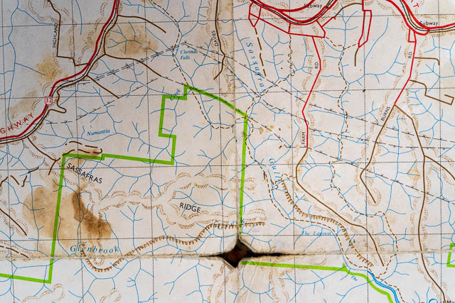
Below is a section of a sketch map drawn by Myles Dunphy in 1961. The purpose of the map was not to show tracks and features but rather place names for the Geographical Names Board to consider.
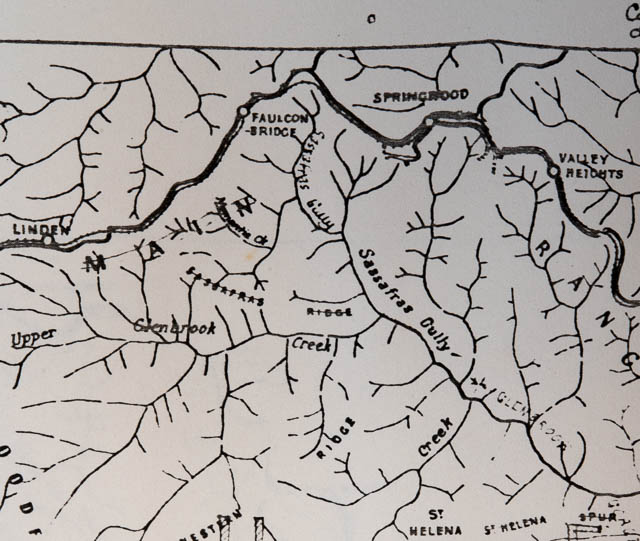
It is interesting that the name “Numantia Creek” is applied to a tributary of the present Numantia Creek. The name “Sassafras Ridge” has been crossed out (it is now an accepted name). Also, “Upper Glenbrook Creek” is used for Glenbrook Creek above The Lagoon.
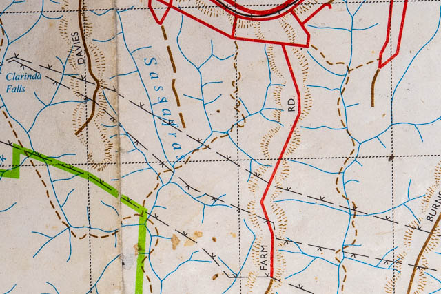
A Blue Mountains Council 1963 tourist map
It is interesting to see what tracks are shown and what are not shown on the above map. It has the original Bee Farm Road track, and the track down Glenbrook Creek and up Martins Lookout. But it does not have the Sassafras Gully Road Track, nor the Victory Track. It does have a track marked on the “Salisbury Ridge” mentioned in the above report, and shows it continuing to the creek. There is old stonework (steps) that leave the present track near a spring (mentioned below) and they go up the ridge towards Davies Avenue.
The Blue Labyrinth Map was published by the Lands Department in 1963 and shows the place names that were approved following Myles Dunphy’s earlier suggestions.
Here is a small section of the map showing Sassafras Gully.
Looking a bit closer shows that Sassafras Gully Road is not marked, but the track from where the road should be is marked. The Victory Track is marked but the junction of the tracks is not accurate.
One egregious error on this map is that “Bee Farm Road” is marked as “Farm Road” and Yondell Avenue is not marked. There is a Farm Road, but that goes off Burns Road to Martins Lookout.
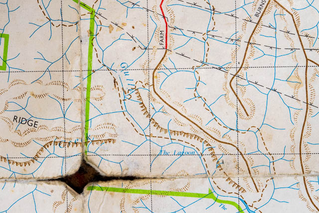
The Wiggins Track is marked and also the Magdala Creek Track (although with the wrong number of creek crossings, there should be 9). Clarinda Falls is marked, but not Numantia, Magdala or Martins Falls. “The Lagoon” is named – but in the wrong place.
New Names
From The NSW Government Gazette, 24 October 1969 –
Proposed –
The Lagoon name be discontinued
Sassafras Gully changed to Sassafras Creek
Proposed names be adopted –
Clarinda Falls
Lawson Lookout
Lost World Lookout
Bunyan Lookout
Magdala Creek
Magdala Falls
Martins Falls
Numantia Creek
Numantia Falls
Perch Ponds
Western Creek
In The NSW Government Gazette, 28 November 1969 the new names were adopted.
In The NSW Government Gazette 30 Oct 1998, Page 8620 –
Fairy Dell Reserve named
Note that the name “Fairy Dell” is much older. It appears on the 1885 map from J E M Russell’s Guidebook (see above).
The Stone Cross Mystery
The Blue Mountains Gazette had a report from members of the Springwood Bushwalking Club finding a large stone cross on a side track to the Sassafras Gully track and they wondered about how it came to be. A later report –
2018 – Stone Cross Mystery Solved
Victor Michniewicz is the author of St Columba’s College Springwood: The story of a local landmark. He said the cross had been built by seminarians from St Columba’s, who in the early years of the 20th century, would walk to the gully each St Patrick’s Day. He couldn’t say exactly when it was built but knows it is at least 80-plus, after finding a reference to the cross in the 1936 annals of St Columba’s, written by the students
This cross is reached on an old track – there is still some old stone steps in places. I think it is likely that it is part of what was once a separate access track into the valley. This could be the Salisbury Ridge Track mentioned above.
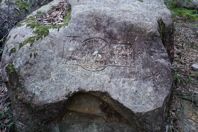
Paddy the Dog Memorial
Observant walkers will have noticed an engraving on a rock face a short way down the track from Sassafras Gully Road.
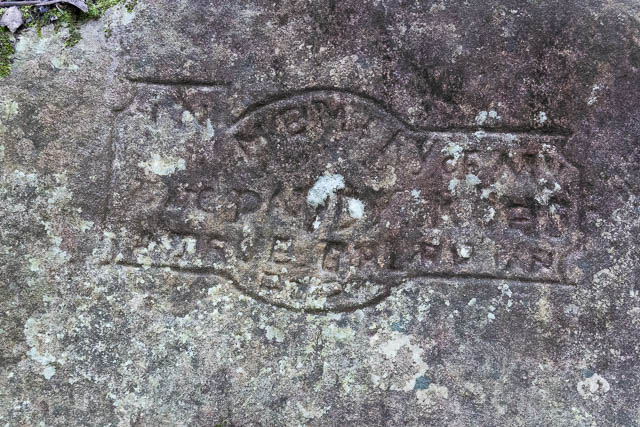
It says something like “In Memory of Paddy/ a true pal/ 1917/R. Scott”, and is one of three such memorials carved by Robert Scott after his dog Paddy died. More information can be found in Hut News.
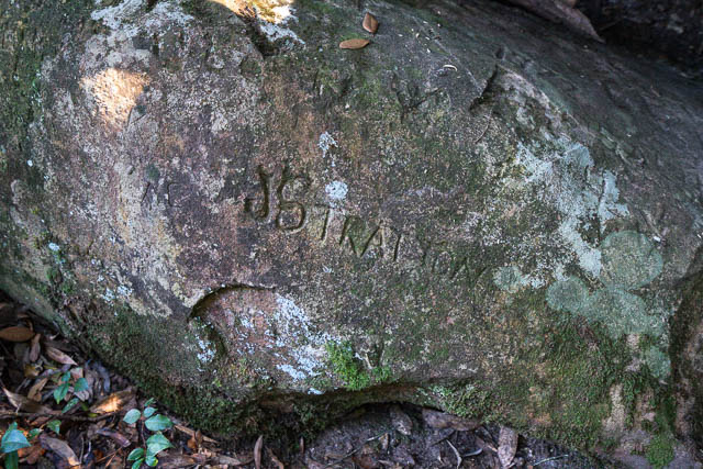
Strattons Amphitheatre
This is located a short way from the main track. There are remnants of old stone work indicating that once a side track went to this spot. The track ends at an amphitheatre where further progress is blocked by a waterfall.
There is a large cave nearby with lots of chiselled graffiti.
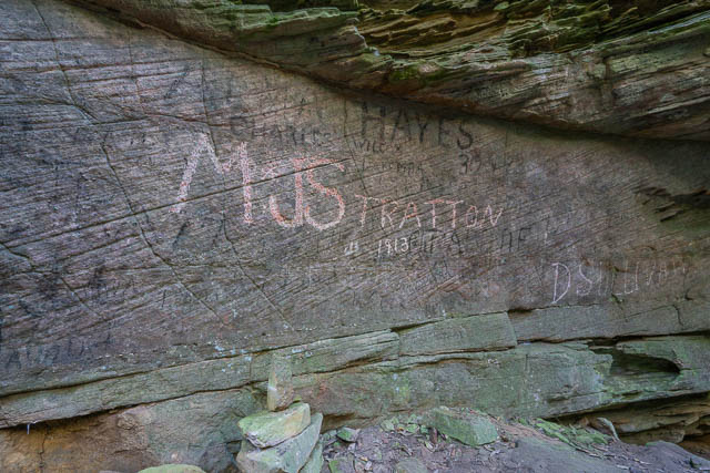
Most prominent in the graffiti is the chiselled inscription “M and J Stratton, 1913”. This refers to Mabel and Joe Stratton. They lived on Grose Road not far past the present site of Springwood High School.
There are plenty of caves in tributaries of Linden Creek near their property with the “Stratton” inscription. There is also a “J Stratton” chiselled inscription in Wentworth Cave on the Grose River.
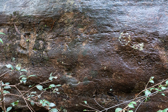
Psalm Rock
This is another mystery. A short way down from where the Kings Link Track leaves the valley track below Martins Lookout, on the true left side of Glenbrook Creek can be found a boulder engraved with a psalm from the Bible.
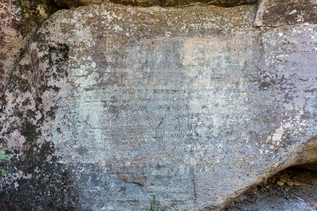
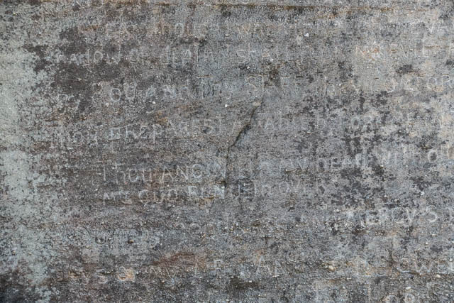
This is mentioned in Bruce Cameron’s book on the history of the Blue Labyrinth but the author, and no one else, seems to know who went to the trouble of carving this inscription.
From above, we know that Joe Stratton was handy with a chisel and visited the area, Could he have made the inscription? I think it is unlikely – I compared the letters with those in the Amphitheatre and they don’t seem to match that well. I think it is more likely that it was done by a seminarian from St Columbus College.
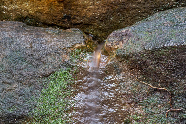
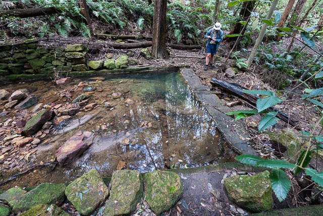
The Spring – “Ye Olde Fountaine”
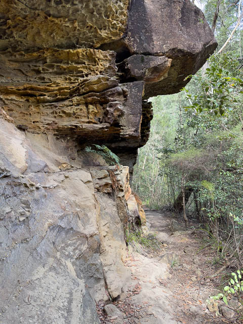
The track from Sassafras Gully Road at one point passes through an overhang. There is often water dripping down from the roof, but at the far end of the cave is a natural spring. I have never seen the flow of water at this spring stop. Often a leaf is placed in the flow to make the water easier to drink or fill a bottle.
Nearby is another “J Stratton” chiselled inscription of his name and also “Ye Olde Fountaine”.
It seems very likely to me that Joe Stratton carved the “Ye Olde Fountaine” inscription. The style of the letters seems the same.
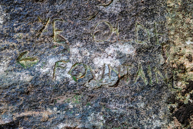
When I first visited Sassafras Gully in the early 1960’s I can remember getting water from the spring. I seem to recall that it flowed much better back then.
More Inscriptions
The following inscriptions have been carved on a rock face along Magdala Creek –
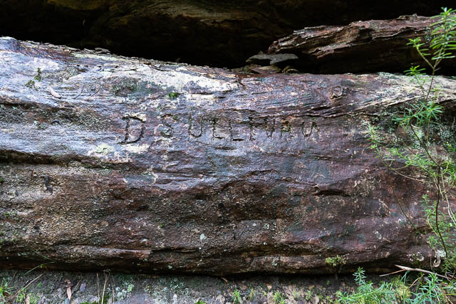
The first one is “D Sullivan” and the second, which is harder to read, is “J Stratton”. Joe Stratton was well known in the Springwood area. Perhaps they had both been employed at one time to work on the track? Strattons Amphitheatre also has a”D Sullivan” inscription.
St Helena
This is a very interesting place, not far from Sassafras Gully. Good information on it can be found on this website.
Nearby is the Kings Link Track which goes from Glenbrook Creek to Bunyan Lookout, and The Lost World Lookout. The tracks built by John King, assisted by my uncle, Perc Thomas, and opened in 1991.
On the spur up to Lost World Lookout from Western Creek is a small camp cave – the Sharks Head Cave.
The Batman Track
This track goes from the Magdala Creek Track to Batman Park. Probably made by locals as a route into Sassafras Gully in the 1980’s.
Fels Pass and Tracks behind Blue Gum Lodge
A number of tracks are marked on Open Street Maps behind Blue Gum Lodge at Springwood. The lodge was a Christian youth centre, so the tracks were probably used by people staying at the lodge.
But there was an earlier track known as “Fels Pass“. Frederick Fels had a property at the present location of Springwood Public School and also Blue Gum Lodge. The property, previously owned by Frederick Somers, was called “Fels Ridge” and was purchased in 1889. There is also a street called “Fels Avenue”. This seems to have once been a loop road off the end of “Gloria De Chair Avenue” (present name De Chair Avenue). The present road is an extension off De Chair Avenue rather than a loop. It sounds like the “Fels Pass” track was constructed by Frederick Fels to connect up his property to the Fairy Dell – Magdala Creek area. Information on the Fel’s family can be found here and here.
Frederick Fels, a financier, originally from Poland, was prominent in the Springwood area and was a patron of many local clubs (The Rifle Club, Cycling Club) and involved with The Springwood School of Arts. He died in 1915 at the age of 36. There was an interesting court case in 1919, where Fel’s widow, Dora sued John and Thomas Coyle for malicious damage (removing quarried rocks from the property). The Fels Ridge house is the present Blue Gum Lodge (although the original building may have suffered some bushfire damage in 1968.
The Blue Mountains Heritage Register Review states that the Fels Pass Track was constructed between 1905-1909
In that area is cave used as a residence by Robert Scott and another memorial engraving to his dog Paddy (see above). The cave can be found along the unformed section of David Road (from the east side). The memorial to Paddy is on enclosed private land nearby.
These tracks are linked to the Magdala Creek track. The tracks join at the top of small waterfall, where there is a wooden sign for Magdala Creek.
The waterfall has been named Springwood Falls on a map of the trails behind Blue Gum Lodge. Carved into the rock on the side of the waterfall are several inscriptions – “R Foy”, “MB” (or “ME”) and “TW”.
Further up this small tributary the remains of concrete dam can be found.
Track Workers
This is a list of people that have or may have worked on the tracks over the years –
- Various members of the Wiggins family
- Thomas Coyle
- Joe Stratton
- D Sullivan
Thomas Coyle was a Springwood quarryman and labourer and was employed by the council to work on the tracks. There is a “T Coyle” engraving at “Ye Olde Fountaine”. There are engravings by Stratton and Sullivan at various places along the track network – so it is likely they engraved their names while working on the tracks.
Fantastically interesting post! It ties together so much interesting info in such a readable and visual way. I love the past-present connections you make. Many thanks!
Hello David.
I would love to know the locations of the Indigenous rock carvings and cave art. Would you be able to give me the locations as I would love to see them. I know they need to be kept secret to stop vandalism, so I wont tell anyone where they are. I have added my email and any information would be greatly appreciated.
Good morning David
From your history of Sassafras gully:
“The other location is in a side creek, known as Parkers Gully, coming in from the west just below Clarinda Falls”.
This gully contains Rainbow Cave and an aboriginal art site. Do you know where the name Parkers Gully originated? Who was Parker?
The name is not known to the Springwood Bushwalking Club who regularly walk in this gully and refer to it as an unnamed creek.
Thanks Bob Whiting
I have seen the name used in various documents – in relation to the Aboriginal site I think. Eg – see this document. I do not know how it got that name – but perhaps some sort of corruption of the name “Parkes” (the name of the other gully – the one where the Victory Track descends).
Wonderful to read these accounts. I spent 18 living on the edge of Sassafras Gully and now certain sections well. Love reading the history here, thanks
#know that should have said!
between you me, and the gidgee tree, i have heard, on excellent if despondent authority, that many indigenous sites, now the site of the expanded GWH, were literally just bulldozed through, to create the lovely double lane sections… hmmm
Thanks for such detailed information on he area. I did a walk there yesterday and saw the inscription to Paddy. Thanks to this blog, I found the answer I was looking for.
re Smiths Shelter Hut: I have been researching Thomas Fleetwood Smith (T F SMITH) who was a brother of an ancestor. Smith was an active community figure in Springwood (as well as ran a bootmaker shop) from around 1900 to 1910 and was a trustee for Sassafras Gully in 1904 (and maybe other dates). I wonder if Smiths Shelter Hut is named after him – or some other Smith?
I think it quite likely that the shelter mentioned could refer to T F Smith. The photograph calls it “Sassafras Rest House” and the meeting notes reported in the newspaper article refer to it as Smiths Shelter Hut. It is my speculation that they are one and the same structure. The trustees may have used the name “Smiths Shelter Hut” to honour a former trustee that may have had a role in its construction.