
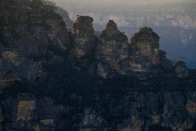
The original plan for the June Long Weekend was to head out to the Gardens of Stone. However, some of the other people on the walk got sick at the last minute, so I had to change plans. On the Friday night I caught a train up to Katoomba and then walked out to Cliff Drive and camped out on Malatia Head.
My plan was to get up early and take some dawn photos and then head down Furber Stairs and walk around to the Ruined Castle via the Federal Pass Track and then climb onto Mt Solitary and camp at Chinamans Gully. On the second day, I would continue along Mt Solitary, drop down off the Col and then head down to the Kedumba Campground and spend Sunday night there. On the last day I would walk out via Kedumba Pass.
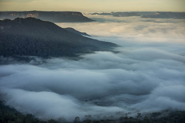
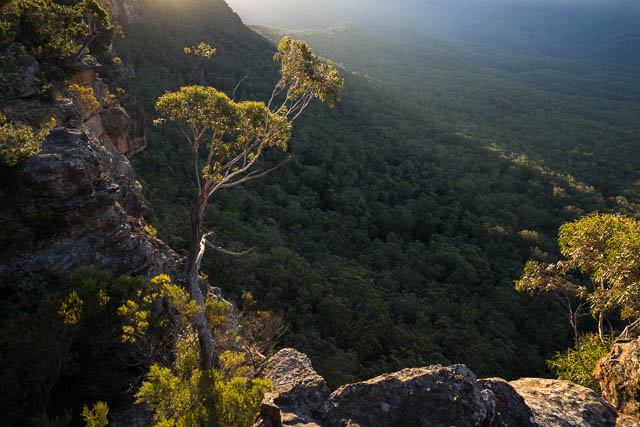
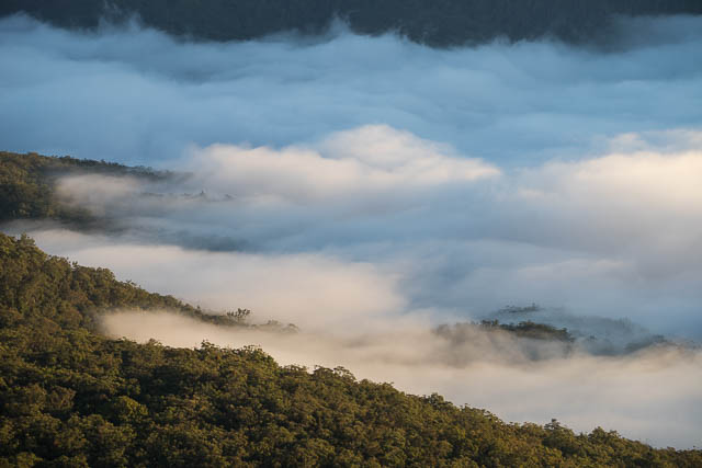
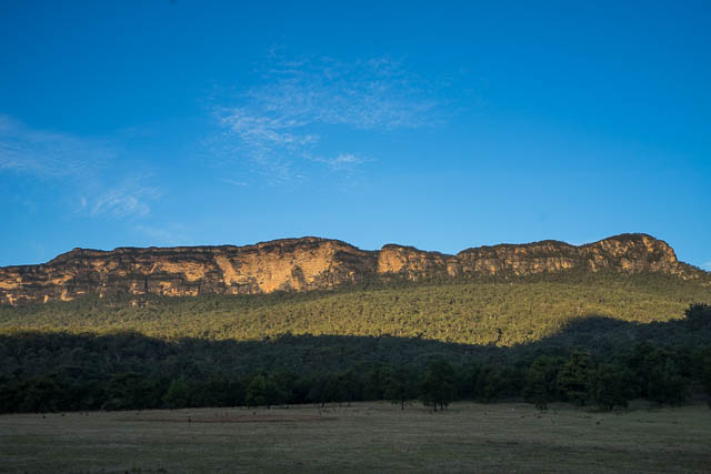
I hadn’t scouted any campsites out on Malatia Point, and when I arrived there late at night, I didn’t find any really good spots. I ended up pitching my tarp on the track. It was an exposed site, but the night was very still. I hoped the still conditions would be conducive for some valley mist the next morning. When I awoke, there was some valley mist, but it was a tiny amount and it was a long way down the valley. Nevertheless, I got up and wandered around with my camera and took a few photos. This is one place I will return to, perhaps at a different time of the year?
After a quick breakfast, I packed up and walked back the short distance to Scenic World and a little further to the old Solar Observatory (now a kiosk) and then descended quickly down the steep Furber Stairs to Federal Pass. At the bottom, it was before 9 am and it was strange being on the track and walking past the bottom terminus of the scenic railway and not seeing a single other person.
I continued along Federal Pass. Walking around the Landslide, I looked up at the massive wall above – the Dogface, and noticed a portaledge anchored to the rock about half way up the face. There was a rope from the top of the cliff to it, and another from it to the bottom. Climbers sieging the Dogface?
As I continued along the track, I was hoping some fungi would be out. The track passes through a nice section of rainforest. However, very little was out. I only stopped once – to photograph a nice slime mould on the end of a log. I continued on to the Ruined Castle turnoff, and passed some other walkers trying out the new toilet facilities installed there. I stopped a short way further on at the upgraded Ruined Castle Campsite. Here, there is another new toilet and two shelters together with picnic tables. The shelters are not there to provide shelter, but rather their roof area is being utilised to collect rain water and direct it into large storage tanks. I stopped for a drink and a short break.
Then I continued on my way, climbing up onto Mt Solitary. This climb is always enjoyable. The views get better as you ascend and you soon forget your struggle with gravity. Another short photo break at the top and then I continued along to the head of Chinamans Gully for lunch and to set up camp.
I spent a lazy afternoon wandering around – between Melvilles Lookout, just to the south of the campsite and the lookout to the north at the end of Chinamans Gully. Both are great vantage points. Melvilles Lookout is named after pioneer bushwalker Ninian Melville. He was an early mapmaker and the founder of the Coast and Mountain Walkers of Sydney.
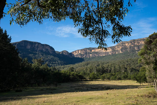
During the afternoon, a lot of other walkers also set up their camp at Chinaman Gully. It is a popular campsite, with good reason. Melvilles Lookout is a short distance to the south and offers outstanding views of the Southern Blue Mountains. You can see Lake Burragorang, The cliffs of Bimlow Tablelands in the Blue Breaks, The Coxs and Kowmung Valleys, the distant sentinel of Mt Colong, and then the full extent of the Gangerang Range including Mt Cloudmaker and Kanangra Walls. Magnificent! If the weather turns bad – a short way down the gully are three sandstone overhangs, These camp caves provide good refuge during spells of bad weather. Chinamans Gully itself provides a reasonable source of drinking water – although it is probably wise to draw your water from a small side creek near the cliff line. This side creek is only 5 minutes walk down the gully, and just past it is the second lookout – this one is to the north and it has good outlook over the Jamison Valley. You can also see The Ruined Castle and Castle Head. The drawback to the campsite is that it is a bit overused, or perhaps rather a bit misused. It is often camped in by inexperienced walkers and they have not shown great thought. Some huge campfires have been built – which has reduce the available area for camping. Also many campers seem to rake the leaves off their site before setting up their tents. The has led to some of the ground becoming hard and compacted so any rain will just run off and not go into the ground. And as you wander down the valley the site of exposed toilet paper is certainly worrying. There is some even in the camp caves! It is not too difficult to leave the catchment area of the creek for toilet purposes. But Chinamans Gully has been like this for many years – and it is still a nice place. I don’t think it has changed too much over the years. I can remember one trip back in the 70’s when the party I was in didn’t think too much of the condition of the campcaves. We spent a while collecting a lot of rubbish – mainly tins and bottles and carrying it out. We carried out several large bagfuls. There is certainly less of that sort of rubbish now.
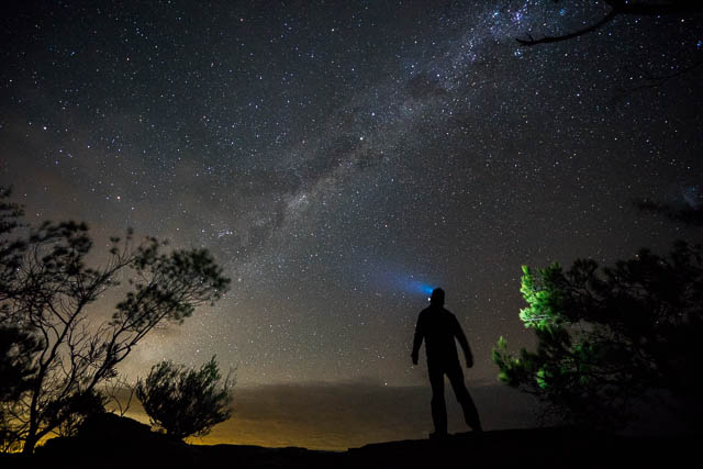
Late afternoon provided a dilemma. Which lookout would be best for the sunset? Neither provides an ideal sunset location at this time of the year – you cannot see the sun actually set, the view is blocked by the bulk of the mountain, but the surroundings are often good. I spent most of my time at the northern lookout. In the early evening, I wandered out to Melvilles Lookout for some astrophotography. This had to be done early as the moon would soon rise.
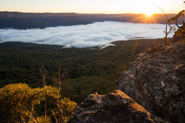
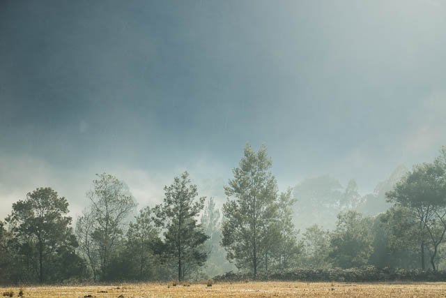
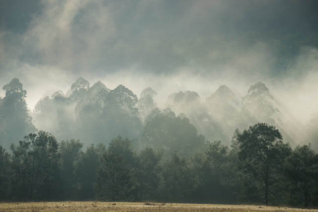
At dawn, I got out of my tarp, and went to Melvilles Lookout to see what conditions were like. This time there was a fair amount of morning mist that had settled in the Burragorang Valley. Would it be in the Jamison Valley as well? I quickly walked down the gully to the northern lookout and arrived just before the sun rose. There was also a fair amount of mist in the Jamison Valley. Nice. It was a cool morning and it was pleasant to be in the Sun’s rays while I photographed. Then back to the south side to Melvilles Lookout for a few more photos.
Despite it being a long weekend, most of the other campers at Chinamans Gully, seemed to be only out for two days. They had packed up early and set off for either Katoomba or Wentworth Falls. I could afford to be more leisurely. I slowly continued along the track towards the Col on the eastern end of the mountain. This is very pleasant walking. Much of the track is close to the northern rim and offers outstanding views. On the way I passed a few small campsites and the larger and very nice campsite at Sing-a-Jinglewell Creek. Then a descent to the Col – a column of rock that provides a good outlook over the Kedumba Valley. I quickly signed the almost full logbook and then started on the very steep descent track.
Part way down is a marked track junction – the main track goes down to Kedumba Creek, and the side track to Kedumba Campground. I headed towards Kedumba Campground. The track was not very distinct and at an old dam I lost it. I should have looked at my map to see the rough layout. It was a first edition 1:25,000 sheet and only had an old track marked. Nevertheless I was not worried and continued descending down to the Kedumba River and then a short way along it to the open country of the former Kedumba Farm.
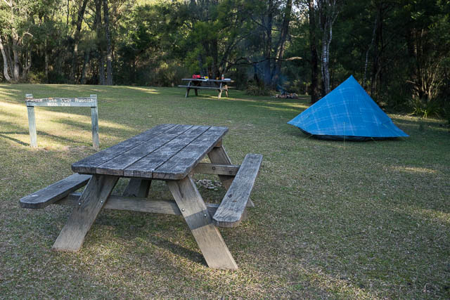
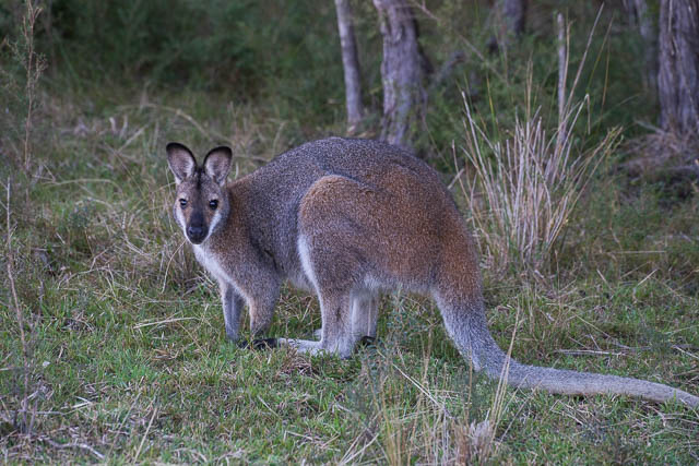
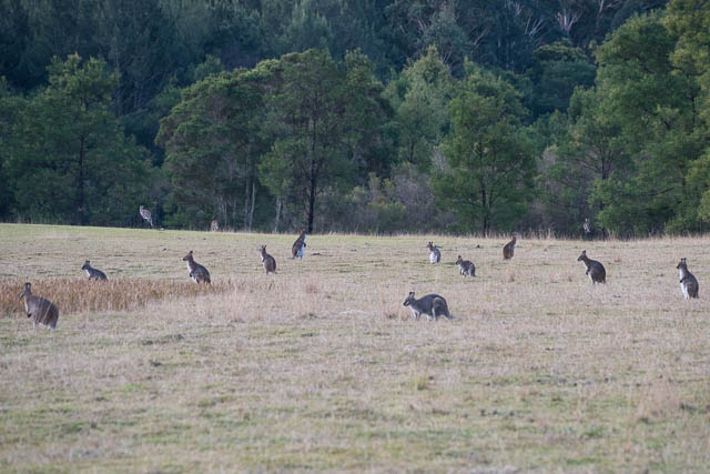
Kedumba Farm is now part of the National Park, and has been set up as an excellent campground. There are some picnic tables and a toilet and a huge area of open grassland to camp on. Last year I had been to the campground on a daywalk and thought it would be good to camp there some time in the future. So it was pleasant to return. I arrived there at lunchtime and enjoyed another lazy afternoon wandering around exploring the area. It is a very beautiful place. Near my campsite there was a large family of wrens darting about. There were also wombats and wallabies. Lots of wallabies. At dusk, I counted a group of more then 50 grazing on the abandoned pasture. Above the massive sandstone walls that flank the Kedumba Valley glowed red.
It seemed a bit odd to be camping at this stunningly attractive place and have it all to myself. And on a long weekend too!
The next morning was again cool, and it seemed to take a long while for the sun to make it down to the valley. But when it did things warmed up nicely. The wrens and wallabies were again out in force. After another photo walk, I had breakfast and a few hot drinks and then packed up.
To get to Wentworth Falls from the campground is a roadbash. Two hours uphill (and a steep hill at that!) via Kedumba Pass to the barrier and then another 80 minutes to reach the village.
More photos from the walk are online on my website staring from this page.
A great account of what sounds like a wonderful walk. I’ve often seen the clearing in the valley that I now know to be Kedumba Campground, so I’ve wanted to check it out for a long time but knew very little about it until today. You’ve inspired my to do it.
For those interested the wallabies are called Red-necked Wallaby (Macropus rufogriseus) and they’re normally solitary but sometimes congregate where there’s good grazing.
I particularly like the night shot of you with the head torch against the stars. Can you please tell me how you did this? i.e what setting/self-timer? and how do you get the correct exposure?
Thanks for your comments. For the night shot – it was more or less trial and error. I Took a few photos without me in it to get the exposure for the stars correct, then I took one with me in the photo. For all of them I used a self timer. The settings were F4, 25 seconds, ISO 6400 (so I must have stood still for a fair while) – I just pointed the beam upwards into the main subject of the photo (the Milky Way) – and parts of the beam scattered off stuff in the air (dust or mist)
Hi Dave, do you know of any websites/maps that have that side track going down to Kedumba campground? My Topo map does not have it–maybe they are letting it grow over. Worried I will miss it leading a group at Easter.
No – and I lost the track on my trip. But its not too hard or dangerous.