I had grown up at Springwood and thought I knew the local area pretty well, but there was one creek that I had not visited – Frasers Creek, near Yellow Rock. I was surprised to find when looking on maps that that Yellow Rock is now a town. In my younger days, it was the name of a road that went to Yellow Rock Lookout.

Yellow Rock Falls
I had heard that Frasers Creek contained a waterfall worth seeing, and a visit to the creek had been on my list of future walks for a long time – but with only a low priority. Bob was keen for a trip, but for various reasons, did not want to venture too far away, so suggested it was now time to do the Frasers Creek walk. Already, when talking about options, we thought the best way would be to take a bike and use that for a quick way to avoid a road bash.
So after a visit to a cafe at Springwood, we drove out along Singles Ridge Road at Winmalee. Bob, dropped me off at the fire trail that leads down to a small tributary creek. He then drove to Yellow Rock Lookout, parked his car and rode the bike back. After hiding the bike in the scrub, we set off.

I think this large colourful fly may be a Yellow-headed Snail Parasitic Blowfly (Amenia imperialis)

It was easy and pleasant walking down the fire road. It led through some nice forest.


We soon arrived at the termination of the fire road. Here, the creek was larger and we thought it may be slow going involving some wading.


But, the walking was relatively easy, mainly along open rainforest banks.


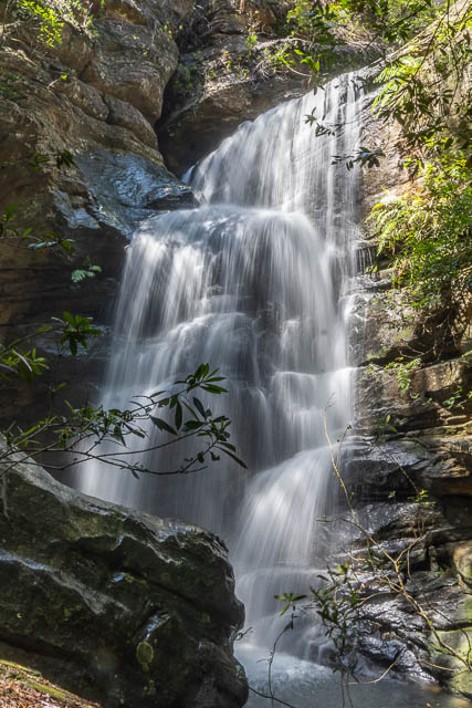
Lower down, we arrived at the falls. They were impressive.


We could see down the waterfall, which was at least 15 m high, but a way down was not obvious. At the top of the waterfall, we saw an old sling that a previous party had used to abseil off. But, with no rope nor abseiling gear, that was not an option for us. So we first checked out a promising ledge on the true right. It didn’t go, and we had to reverse some dodgy scrambling to get back. The true left side did not offer any ways we could see, so we tried a higher route on the true right.
After traversing high up, we found a way down. It did involve some tricky scrambling though. Perhaps there are other easier options? It would have been quite easy to scramble up to Yellow Rock Lookout, but we wanted to see the waterfall from below.
Once back down at creek level, we headed upstream to the falls. They were impressive –


Near the falls we came across a few sections of old hosepipe. The remains of an old irrigation system for an illegal plantation? We then continued on our way downstream. It was slower going than earlier, with some large boulders to negotiate.
And lower down, we reached a second waterfall. This was not as high, and much easier to find a way down.

The creek then started to get a bit slow, so we thought it time to climb out. But first we stopped in a shadey place for lunch.
On the way up, Bob came across the remains of an old benched track. He thought it was an old packhorse track that went from the Nepean River to Yellow Rock Lookout.

At the top, we enjoyed the views from the lookout, and were then grateful that Bob had used the bike, as his car was parked only a few metres away.

This was a walk new to both of us, and quite interesting.

Hi guys luv your comments about the tracks you make,I’m curious once starting on yellow creek trail from single ridge Rd how far walk is the creek line, from what I can see it is Fraser creek and the view looks beautiful.
Kind regards Andrew
We didn’t make any tracks – but a lot of our walk was “off track” – where we made our way through the bush, with minimal impact. To see the distances – look on a topographic map.
Looks like you two have done everything. Appreciate the information and the photos. I went to the end of the firetrail yesterday. It got me wondering what was beyond it.